Transport modeling of accessing forest fires by ground means
_ The protection and development of forest ecosystems in the present economic conditions of Russia are associated with some difficulties. They can be covered by optimizing the allocation of resources. Forest management can be implemented by combining two directions: accessing the forest fire (an optimal access route based on the set of parameters like time […]

Метод учета валежа на линейных трансектах
Для учета запасов валежа на площади используются методы учета валежа на линейных трансектах (Грабовский В. И., Замолодчиков Д. Г. Модели оценки запасов валежа по данным учетов на трансектах //Лесоведение. – 2012. – №. 2. – С. 66-73.). Суть методов заключается в том, что на местности прокладывается линейная трансекта (например, мерная лента, растянутая вдоль поверхности […]

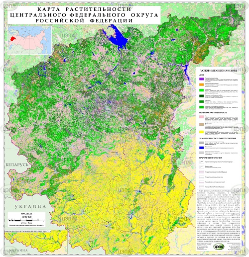
Vegetation mapping of terrestrial ecosystems at the regional level
_ Vegetation mapping is one of the priorities for remote monitoring of condition and dynamics of forest ecosystems. These products provide the basis for the assessment, geospatial analysis and modeling of the taxa forest characteristics, biodiversity, ecosystem functions and services. We have developed an integrated automated methodology of regional vegetation mapping…

Estimation of annual fire Carbon and GHG emissions using satellite derived products
We developed and present our method for Carbon and GHG emissions from forest fires. The method is based on a comprehensive analysis of data on burned forested areas, the degree of fire forest damage and previous fire vegetation fuels (combustible vegetation fractions) of the study area. National fuel maps were created based on the […]

Field guide of forest types of the European Russia
The field guide is based on a big amount of factual information from various sources: – original geobotanical samples united into the FORUS base (Center for Ecology and Productivity of Forests RAS, Moscow; Institute of Mathematical Problems of Biology, Pushchino); – published geobotanical samples and pivot tables; published text descriptions of specific forest types […]

Natural fire hazard of forest area maps updating approach
In forestry of Russia, for assessing forest areas according to the degree of fire occurrence the natural fire danger classes are used. The class of natural fire hazard (KPPO) of a forest fund is determined by the type of ground vegetation cover, forest specie composition and age, land categories and a number of other characteristics […]
")
Regional information system of fire-prevention arrangement of forests for Irkutsk region (test region)
A regional forest fire monitoring information system was created in the regional console of the dispatching control of the Forest Fire Center of the Forestry Agency of the Irkutsk Region in 2013. The system consists of: (1) Web module of centralized collection and display of information on the fire-fighting objects of the forest workstation […]

Estimation of the probability of forest fires approach
We are conducting research and adapting various approaches to assessing the probability of forest fires. The aim of the research is to develop methods for assessing the probability of forest fires in relation as for national (federal level) as some regions (federal districts and subjects of the Russian Federation). Such algorithms as a deterministic […]